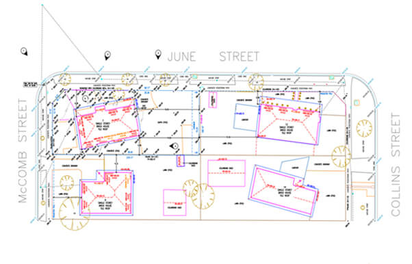
Lesecta Surveying approached QeCAD with the objective of converting raw drone-based survey data into accurate, well-structured AutoCAD drawings. The intent was to create dependable site documentation that the architects and designers could directly use for planning, design development and coordination.
The project comprised the following key buildings and features:
Conversion of drone survey data into AutoCAD drawings
Site layout drafting with existing conditions
Annotation of key site elements and levels
Inclusion of neighbouring property references
Preparation of clean, layered CAD files for design use
→ Raw survey data including height and datum information.
→ On-site existing condition details.
→ High-resolution site photographs.
→ Drone videos capturing top and oblique views of the site.
The client supplied comprehensive survey information captured through the drone technology, offering a detailed understanding of the site’s topography and existing conditions. This included height data, datum references and extensive visual documentation through photographs and aerial videos.
QeCAD’s team meticulously interpreted the raw survey inputs and translated them into precise AutoCAD drawings. Every visible site element—such as structures, boundaries, terrain variations and adjacent property features—was carefully identified, verified and represented. The drawings were organized with clear annotations and logical layering thus ensuring that they were easy to navigate and ready for downstream architectural and design workflows.
→ Interpreting complex drone survey data into conventional CAD formats.
→ Ensuring accuracy while representing multiple elevation and datum references.
→ Capturing fine site details visible only through aerial imagery.
→ Maintaining consistency between visual inputs and technical drawings.
→ High-accuracy AutoCAD drawings derived from drone survey data.
→ Clearly annotated site plans reflecting existing conditions.
→ Structured, easy-to-use CAD files suitable for architects and designers.
→ Reliable documentation enabling faster design decisions and reduced reworks